
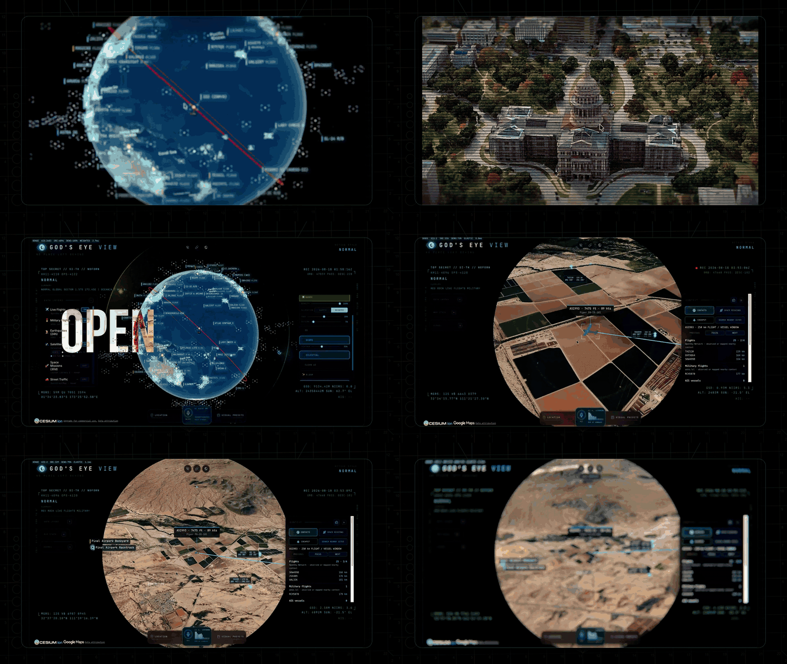
God's Eye View: A Free, Open-Source Spy Satellite Simulator With Real Live Data
TL;DR: God's Eye View is a free, MIT-licensed, open-source 3D globe from Bilawal Sidhu (ex-Google 3D Maps PM) that turns public OSINT feeds into a photorealistic spy-satellite cockpit in your browser. It has 4,400+ GitHub stars and 13 live layers (flights, ships, satellites, fires, CCTV, radio), 10 of which need no API key at all. The killer feature is real-time voice control: you can ask it to track any plane, ship, or satellite and it annotates the globe in natural language. It runs locally on your machine.
If you have ever watched a spy thriller and wondered what that glowing tactical globe actually looks like, this is it, except the data is real. God's Eye View renders the whole planet as a photorealistic 3D globe and layers live public signals on top: aircraft reporting their transponder telemetry, ships broadcasting their position, satellites propagating from current orbital elements, earthquakes from the last 24 hours, even public CCTV cameras projected into the 3D city.
The aesthetic is pure Hollywood. Flip on FLIR mode and the world re-renders through a thermal sensor. Turn on the military HUD and you get an intelligence-style readout. But underneath the drama, every layer is grounded in a public data source you can inspect. The airliner crossing your screen is reporting real telemetry. The camera is installed at a published location. Nothing is classified, and every line of code is open.
What God's Eye View Actually Does
The app is a browser-based client you run locally. Once it is up, here is what you can do:
- Track anything live. Click a plane, ship, satellite, or CCTV camera and the camera locks on, draws a fading trail, and surfaces full metadata.
- Ride in a cockpit. Enter cockpit view on a tracked flight and the camera holds the terrain under you all the way down, switching sensor styles mid-flight.
- Talk to it. Press the mic and ask questions in plain language: "How many flights are over Texas right now?" or "Take me to LAX and select the nearest airborne aircraft." It pulls live scene context before answering.
- Annotate the world. Speak a boundary and it draws the actual polygon, not a circle. Ask a distance and a connector arrow appears with the answer.
- Switch optics. Tap keys 1 through 7 to re-render the whole planet through CRT, night vision, FLIR, Noir, or Snow.
- Stage a mission. One switch pulls back to a full situational picture, then restores your exact view when you leave.
The voice layer is the standout. It is powered by the OpenAI Realtime API and knows what it is looking at: it reads coordinates, street names, active layers, and view scale before answering. Ask "what city is this?" mid-flight and it knows. Click any object and ask "what's this?" and it answers from that object's live telemetry.
The Architecture
God's Eye View is deliberately uncomplicated under the hood. It is vanilla JavaScript, CesiumJS for the 3D globe, Vite as the build tool, Google Photorealistic 3D Tiles for the planet, and the OpenAI Realtime API for voice. No framework, no heavy abstraction, which is exactly what makes it easy to read and hack on.
src/
├── main.js                 # Bootstrap: Google 3D tiles, layer registration
├── ui.js                   # Runtime UI: panels, HUD, styles, control facade
├── hud.js                  # Intelligence HUD + AI scene summary
├── mapStackController.js   # Google 3D / Bing / OSM switching
├── voice/                  # OpenAI Realtime session + 28 voice tools
├── data/                   # One module per layer + management + context store
└── scenes/                 # Cinematic scene director
The client renders live feeds one polling interval behind real time so it can interpolate smoothly between known fixes. Dead reckoning fills the gaps. Satellite positions run through SGP4 propagation with orbit rings that stay locked via GMST realignment, so nothing drifts or flickers. Entity heights run through a real vertical datum, so aircraft park on aprons and cameras stand on street corners instead of floating in space.
The Live Layers
Thirteen layers run on the globe, and ten of them need nothing at all: no key, no account, no signup.
| Layer | What you get | Source | Key needed |
|---|---|---|---|
| Map Stack | Google Photorealistic 3D, Bing aerial, OSM | Google / Ion / OSM | Google (required) |
| Live Flights | Thousands of live aircraft + route history | OpenSky + adsb.lol | None |
| Military Flights | ADS-B military traffic in amber | adsb.lol | None |
| Live Vessels | Thousands of ships worldwide | AISStream | Free key |
| Satellites | ~840-object core catalog, color-coded | CelesTrak | None |
| Earthquakes | Global seismic activity, last 24h | USGS | None |
| Traffic | Live congestion at street level | TomTom + OSM | None (key makes it real) |
| CCTV Mesh | ~800 public cameras projected into 3D | City APIs | None |
| Radio | Geolocated world radio with an analog tuner | Radio Browser | None |
| Bikeshare | Live station availability | GBFS | None |
| Active Fires | Live NASA FIRMS detections | NASA FIRMS | Free key |
| Space Missions | Rolling 30-day launches | Launch Library 2 | None |
| Mapped Installations | Viewport-bounded military-site context | OpenStreetMap | None |
There are also bundled static datasets: 4,351 datacenters, 704 dams, and 712 submarine cables. Some experiences are modeled rather than live, and the app labels them honestly: keyless traffic is marked as a simulation, camera poses are estimated until you calibrate them, and launch ascent playback is labeled "RECONSTRUCTED ESTIMATE."
Privacy and Safety
This is a tool that touches live location data and can hold API keys, so the defaults matter. The dev server binds to localhost, which means your keys stay on your machine. Secret-bearing providers (OpenAI, AISStream, OpenSky OAuth, TomTom, FIRMS) are brokered server-side, and the only credentials intentionally exposed to the browser are Google Maps and Cesium ion, which you are expected to restrict at the provider.
If you share the instance on a LAN, be aware that a LAN-visible server brokers your configured API keys to anyone who can reach it. The README is blunt about this and points you to per-IP throttles and provider-side budget caps before you do it.
The project also draws a clear ethical line. It models events, assets, infrastructure, and systems: aircraft, vessels, satellites, fires, cameras, cities. It does not build features for named-person search, face recognition, or tracking individuals, and pull requests that cross that line will not be merged. People are not a query type here.
How God's Eye View Compares to the Alternatives
| God's Eye View | Google Earth | Flightradar24 | Windy | CesiumJS | |
|---|---|---|---|---|---|
| Price | Free (MIT) | Free | Freemium | Freemium | Free (Apache 2.0) |
| Open source | Yes | No | No | No | Yes |
| Local-first | Yes | No | No | No | Yes |
| Live OSINT layers | 13 | Few | Flights only | Weather | None built-in |
| Voice control | Yes | No | No | No | No |
| Self-hostable | Yes | No | No | No | Yes (library) |
Google Earth gives you the pretty globe but not the live OSINT layers. Flightradar24 is excellent for aircraft but closed and subscription-gated for the good data. Windy is a beautiful weather globe but nothing else. CesiumJS is the engine God's Eye View is built on, but it is a library, not an app: you get the 3D globe and then you build everything yourself. God's Eye View is the only one that ships a complete, self-hosted, voice-controlled OSINT cockpit out of the box.
Where God's Eye View Falls Short (Honestly)
- The Google Maps key is required and metered. It is the one thing you cannot skip, and it is billed by session. The README is honest that costs are small but real, and it tells you to set quotas and budget alerts before sustained use. This is not a fully free tool.
- Voice needs an OpenAI key. Without one the whole app still runs, but the mic button reports voice is unavailable. Realtime audio is usage-metered, and the total depends on model, conversation length, and audio volume. There is a $5 in-app session cap, but provider-side limits are the real backstop.
- It is a dev tool, not a polished product. There is no installer, no one-click download. You need Node.js 24.14.x or 26.x, a
.envfile, and a terminal. The README even suggests pointing an AI agent at the repo to help you set it up. Non-technical users will bounce off this. - The data is delayed, incomplete, or modeled. The README's own warning is blunt: do not use it for flight or maritime navigation, emergency response, or any safety-critical purpose. Live feeds arrive every 15 to 30 seconds, some layers are simulations until calibrated, and terrestrial AIS goes quiet mid-ocean.
- It is young and rough around the edges. The repo was created in June 2026 and has 62 open issues. It is described as "an evolving open-source client for exploration and learning," not a hardened production service.
- Bundled data has license strings attached. The MIT license covers the source code only. The submarine cable dataset is CC BY-NC-SA, which is non-commercial, so if you use the project commercially you need to remove those files or license them separately.
How to Get Started (5 Minutes)
You need Node.js 24.14.x or 26.x and a Google Maps API key. Everything else is optional.
# 1. Clone the repo
git clone https://github.com/bilawalsidhu/gods-eye-view
cd gods-eye-view

# 2. Copy the env file and add your Google Maps key
cp .env.example .env

# 3. Install and run
npm install
npm run dev -- --host localhost --port 4173
Open http://localhost:4173. Cold start settles in under two seconds on a recent laptop. A first-run card offers to stage a mission for you: Live Contacts, Space Missions, or Environmental. Ten of the thirteen layers light up with no key at all, so you can be tracking real aircraft within minutes. Add the free AISStream, FIRMS, and TomTom keys later for ships, fires, and real traffic, and an OpenAI key when you want the voice control.
Who's Behind It
God's Eye View is the open-source release of the project behind the viral "God's Eye View" YouTube series, which has pulled 5M+ views. The creator is Bilawal Sidhu, a former Google product manager for AR/VR and 3D Maps, a TED curator and host, and an a16z scout. He open-sourced it after polling his audience, who were not subtle about wanting the code. The repo is the baseline, it stays open, and the stated goal is for people to break it and bolt on layers the original author never imagined.
The Bottom Line
God's Eye View is the rare open-source project that looks like a movie and is backed by real data. It turns a pile of public OSINT feeds into a single, navigable, voice-controlled place, and it does it locally, under your control, with the source fully inspectable. For anyone curious about geospatial intelligence, OSINT, or just what a live 3D globe can do, it is an impressive starting point.
It is not a finished consumer product. It needs a terminal, a Google Maps key, and a tolerance for data that is sometimes delayed or modeled. But if you have been looking for a self-hosted alternative to Google Earth, a free way to explore live flight and satellite data, or just a fun open-source project to tinker with, this is the one to try.
Prefer to skip the setup? God's Eye View is also catalogued in our directory with the key facts in one place.
Looking for other free open-source tools? Check out our coverage of OpenWorker for a free AI coworker that finishes tasks, and pxpipe for cutting Claude Code token costs.